
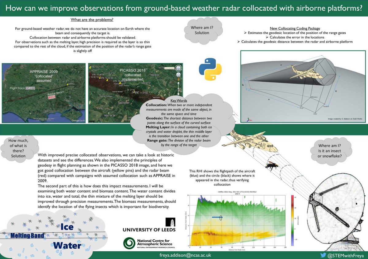
Summary
This is targeted at a radar conference audience, describing a new approach to improved, precision measurements of radar beams with collocated observations from airborne platforms.
Transcript
What are the problems?
For ground-based weather radar, we do not have an accurate location on Earth where the beam and consequently the target is.
Collocation between radar and airborne platforms should be validated.
For observations such as the melting layer, high precision is required as the layer is so thin compared to the rest of the cloud, if the estimation of the position of the radar’s range gate is slightly off
Where am I? Solution
New Collocating Coding Package
- Estimates the geodesic location of the position of the range gates
- Calculates the error in the locations
- Calculates the geodesic distance between the radar and airborne platform
How much, of what is there? Solution
With improved precise collocated observations, we can take a look at historic datasets and see the differences. We also implemented the principles of geodesy in flight planning as shown in the PICASSO 2018 image, and here we got good collocation between the aircraft (yellow pins) and the radar beam (red) compared with campaigns with assumed collocation such as APPRAISE in 2009.
The second part of this is how does this impact measurements. I will be examining both water content and biomass content. The water content divides into ice, water and total, the thin mixture of the melting layer should be improved through precision measurements. The biomass measurements, should identify the location of the flying insects which is important for biodiversity.
Where am I? Is it an insect or snowflake?
This RHI shows the flightpath of the aircraft (blue) and the circle (black) shows where it appeared in the radar, thus verifying collocation
Key Words
Collocation: When two or more independent measurements are made of the same object, in the same space and time
Geodesic: The shortest distance between two points along the surface of the curved surface
Melting Layer: In a cloud containing both ice crystals and water droplet, the thin middle layer is the transition between one and the other
Range gate: The division of the radar beam by the range of the target
Freya I. Addison
Freya is a final year student who is using the shape of the earth, geodesy to improve observations between ground based radar and airborne platforms for meteorology and aeroecology.
Email: Freya.addison@ncas.ac.uk
Twitter: @STEMwithFreya
Organisation: National Centre for Atmospheric Science